July 8 - 21, 2021
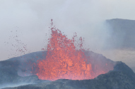
This trip was originally planned for July of 2020 but that one had to be canceled. I was happy to be able to reschedule and use my credits for the flights and trekking huts. An added bonus was the active volcano that started erupting in March 2021!
Reykjavik.
I started and ended the trip with two-night stays in the capital city
of Reykjavik. At the beginning of the trip, I took a short boat
tour to see puffins, visited the Flyover Iceland simulation, and took a
hike out to the active volcano on Reykjanes Peninsula not far from
Reykjavik. At the end of the trip, I
took a one-day bus tour of the Golden Circle. The Golden Circle
is a route near Reykjavik that includes waterfalls, geysers, and
Þingvellir National Park.
Laugavegur and Fimmvörðuháls trails. These two trails are the most well known long distance trails in Iceland, stretching a total of about 50 miles from Landmannalaugar in the highlands to Skógar on the south coast. Being that there were 6 days of backpacking, where I moved from hut to hut, mileage averaged only a bit over 8 miles per day. There were lots of ups and downs, but elevation gain was generally not that great. The highest point was around 3500 feet elevation, and I ended the hike near sea level in Skógar.
After
arriving by bus in Landmannalaugar, I did a day hike to the summit of
Blahnúkúr for some great views before starting the Laugavegur trail the
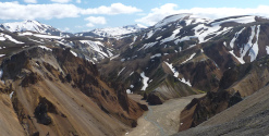
next day. The first two days of the Laugavegur trail is through a
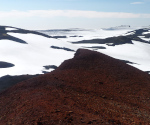
volcanic area, with mountains of interesting colors, and steam vents
and hot pools near the trail. A fair amount of snow is crossed as
the trail gets up to above 3000 feet elevation in this area. The
next two days crosses less interesting terrain, with several river
crossings that can be challenging but weren't too bad when I did
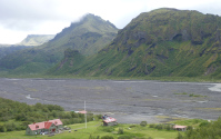
them. The Laugavegur trail ends in Þórsmörk, a popular area with three huts and numerous day hikes. I spent two nights in Þórsmörk,
and did the Tindfjöll Circle trail followed by a hike to the summit of
Valahnúkur on the "rest" day between. Next day I started on the
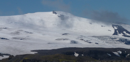
Fimmvörðuháls trail, which first heads up over a 3400-foot pass between
Eyjafjallajökull and Mýrdalsjökull, two ice caps covering volcanoes. Eyjafjallajökull
erupted in 2010 and disrupted air travel in Europe. While at the
pass, I hiked up one of the new craters (Magni) formed during that
eruption. There was quite a bit of snow to cross in the pass area
before reaching my last hut, not far below the pass. The second
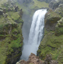
day of the Fimmvörðuháls trail was amazing, as most of it follows the
Skógá river, which goes over some 26 waterfalls, ending with the well-known Skógafoss waterfall right at the town of Skógar. I spent my last night of the trek in a hotel in Skógar where I enjoyed a nice dinner at the hotel's restaurant. A bus took me back to Reykjavik the next day.
I stayed in huts operated by Ferðafélag Íslands.
These huts include mattresses (bring your own sleeping bag), some sort
of bathroom facilities (most had running water and hot showers), and a
fully stocked kitchen with stoves. You carry your own food,
although some food items (mostly snacks) can be purchased in the
huts. Some huts have limited space so the mattresses can be
packed fairly close together. All in all, it was a comfortable
way to do the trek. Each hut has a campground nearby, so the
other option is to bring a tent. I stayed in the following huts:
7/11: Landmannalaugar hut
7/12: Hrafntinnusker hut
7/13: Álftavatn hut
7/14: Emstrur hut
7/15-16: Þórsmörk Langidalur hut
7/17: Baldvinsskáli hut on Fimmvörðuháls
The weather was pretty good by Iceland standards. I had whiteout, high wind, and sleet on the first day of backpacking (Landmannalaugar to Hrafntinnusker), and it rained lightly most of the day on the third day (Álftavatn to Emstrur). Weather was pretty good the rest of the days, with great weather in particular the day I went up to Fimmvörðuháls pass! On the last day descending to Skógar, the sky was blue up high but there were low clouds that I passed through on the way down.
I did not rent a car in Iceland, instead using bus transport for the tours from Reykjavik (including the active volcano hike) and to and from the Laugavegur and Fimmvörðuháls trails. The international airport is 45 minutes from Reykjavik, so I also used bus transport to and from the airport.
Map
Below is an interactive map of the trek. The red tracks are backpacking (carrying full pack), the magenta tracks are day hikes. The brown building symbols are the mountain huts, including some that I did not stay at. The green bed symbol is the hotel in Skógar. I started at the top in Landmannalaugar and ended near the coast at the bottom in Skógar.
Click here for a full-page version of the interactive map
Click here to download the kml file of the tracks to load into other software like Google Earth