October 21 - November 9, 2023
This
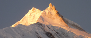
trip involved 12 days of trekking in Nepal, making a circuit around
Manaslu, the 8th highest mountain in the world at 26,781 feet (8163
meters) elevation.
Kathmandu. The
trip started (after long flights) with two nights in Kathmandu.
We did a bit of touring around Thamel the day in between. At the
end of the trek we had a final night in Kathmandu before leaving for
home.
Manaslu Circuit. After the two nights in Kathmandu, we had a long road trip via bus and jeep to the start of the trek in Macchu Khola. The trekking starts at an elevation of 2950 feet at Macchu Khola. It follows the Budhi Gandaki river upstream for the first part, reaching an elevation of 16,843 feet (5135 meters) at Larkya La. We took our time going up to allow time for acclimitization, having extra days in Samagaon and Samdo where we stayed two nights each with a day hike higher between. On the day we crossed Larkya La, we awoke at 4am and started walking at 5am in the darkness. It's one of the longer days, and skies tend to be clearer in the morning.
The circuit then follows the Dudh Khola river downstream to
where it flows into the Marsyangdi river. Here we joined the Annapurna
Circuit in Dharapani. We
had an extra day of trekking at the end from Dharapani to Jagat on the
Annapurna Circuit that usually not part of Manaslu Circuit treks since
you can take a jeep out from Dharapani. It was interesting to see
that
portion of the Annapurna Circuit again after doing the circuit the
other direction 10 years ago. We opted for an evening jeep ride
from Jagat to Besisahar rather than waiting until the next
morning. It was a brutal two hours
on extremely rough road! At least we couldn't see the sheer drops
off the side of the road in the darkness. Next day we continued
back to Kathmandu in a bus.
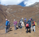
Our group consisted of eight trekkers, three guides, and five porters. We stayed in guest houses every night, generally with rooms with two twin beds and bathrooms reached outside. In Dharmasala, the stop right before Larkya La pass, we had a room with room for four, side by side, without much other space in the room. Total trekking distance was around 82 miles, with another 10 miles or so of acclimitizing day hikes.
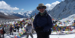
We
saw Manaslu from many different angles, starting with a view from the
road just outside of Kathmandu while driving to the start of the
trek. On the trek, we first saw the peak from just past Sho, with
continued views over Larkya La and down to Bimthang. Local
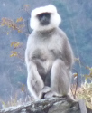
wildlife seen included Nepal gray langur monkeys, Himalayan tahr, and
blue sheep. Domesticated animals included horses, mules, cows,
yaks, goats, and chicken. Weather was mostly excellent, with no
precipitation other than some snow in the afternoon in Dharmasala.
Doha, Qatar. On the way home I had a 19-hour layover in Doha, so I left the airport and spent an afternoon and night in the city. I toured the National Museum of Qatar and browsed the interesting shops in Souq Waqif.
Map
Below is an interactive map of the trek. The red tracks are backpacking (moving to a new location), the orange tracks are day hikes. The brown building symbols are the guest houses that we stayed at. The route resembles an inverted "U" shape. We started the trek in Macchu Khola at the bottom right end of the "U" and ended in Jagat at the bottom left end of the "U". There were two villages called Jagat, the other being our stop after the first day of trekking.
Click here for a full-page version of the interactive map
Click here to download the kml file of the tracks to load into other software like Google Earth