May 18 - June 1, 2019
My
visit to Peru can be broken into three parts.
Cusco.
Cusco is the largest city in the area with a population of about
500,000. It lies at close to 11,000 feet elevation. This
city served as the starting and ending point for the trip. At the
start, we had two nights in a hotel for acclimation to the altitude and
with a tour of the city and surrounding Inca sites on the day between.
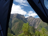
Choquequirao to Machu Picchu trek. This is a trek in the Cusco area of Peru that first visits Choquequirao, then crosses several passes (highest is Yanama Pass at 4600m or around 15,200ft) through mountains and valleys to reach the hydroelectric plant near Machu Picchu. Total distance is around 65 miles (105 km). We spent a total of 9 days on the trek, with 8 nights camping in tents. I was with a guided group with stock support. We only needed to carry things that we needed each day, with the rest of the gear and food transported by mules. We were supported by one guide and 7 crew as well as 11 stock (I believe 10 mules and one horse).
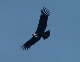
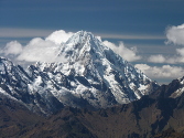
The weather on the trip was excellent, May being the beginning of the dry season. We had one evening/night of on-and-off rain (second night of the trek), with some thunder and lightning after dinner. Other than that, there were only a couple of sprinkles one afternoon. Low clouds were typical in the mornings in the high mountains, with some clearing later in the day allowing us some great views of snowy peaks. The end of the trek had some views of Salkantay, one of the highest mountains in the area with an elevation of 6271m = 20,574ft.
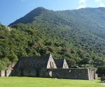
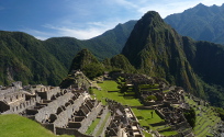
Machu Picchu.
The best-known Inca site and best-known Peru tourist destination in
general is Machu Picchu. After the trek, we took the railroad
from hydroelectric to Aguas Calientes, a tourist village below Machu
Picchu. Aguas Calientes has no road access, only railroad and
trail. But it has busses that make the trip from the village up
numerous switchbacks to Machu Picchu, which is perched on a ridge above
the village. We took the bus to Machu Picchu the following morning, and
did two short hikes before touring the site itself. We hiked to
the Sun Gate, which is the end of the classic Inca Trail. Then we
hiked to the Inca Bridge, which was an escape route from Machu
Picchu. After finishing at Machu Picchu, we took the bus back
down to Aguas Calientes, then the train to Ollantaytambo where a van
met us for the ride back to Cusco.
Map
Below
is an interactive map of the trek. The red tracks are walking,
the blue tracks are vehicle. The light blue track around
Choquequirao is our day trek on May 23. The
green tent symbols are accommodations for each night. We started
at the bottom, at the end of the road north of Cachora, and ended at
top right at the hydroelectric train station. From there we took
the train to Aguas Calientes (Machupicchu Pueblo on the map). We
visited Machu Picchu on May 30, then that evening took the train and
then a van back to Cusco.
Click here for a full-page version of the interactive map
Click here to download the kml file of the tracks to load into other software like Google Earth