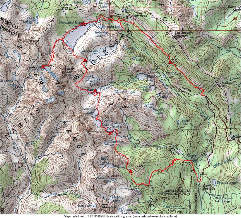
Minarets and Ritter Range 2010
August 27 – Devils Postpile to Superior Lake
August 28 – Superior Lake to Minaret Lake
August 29 – Minaret Lake – snow!
August 30 – Minaret Lake to Ediza Lake
August 31 – Ediza Lake to Garnet Lake
September 1 – Garnet Lake to Lake Catherine
September 2 – Lake Catherine to Thousand Island Lake
September 3 – Thousand Island Lake to High Trail
September 4 – High Trail to Agnew Meadows
North of all of our other off-trail trips, this year’s trip found us in the Mammoth Lakes area, just southeast of Yosemite National Park. A very popular segment of the Sierra High Route traverses through here, hugging the eastern slope of the Ritter Range before heading “behind” the range. The Ritter Range is an interesting area, with this range exceeding the height of the actual Sierra Crest in this area. But the watershed on this eastern side of the Ritter Range drains into the San Joaquin River, which flows, to the west. Our trip started at Devils Postpile, an interesting geological formation, and headed up toward Beck Lakes on a trail.
All of the off-trail route for this trip followed the Sierra High Route, from Superior Lake to Lake Catherine. The John Muir Trail stays to the east of this route, and a number of spur trails lead to the lakes of our route. Thus, although we were off-trail most of the time, we had frequent intercepts with trails. Because of the accessibility, we saw probably more off-trail hikers this trip than all of our other trips combined. But that did not detract from the scenic beauty of this area!
We completed our nearly closed loop by taking the “High Trail” back to Agnew Meadows. This trail is part of the Pacific Crest Trail and has nice views across the valley to the Minarets, Mt. Ritter, and Banner Peak that make up the Ritter Range.
The Devils Postpile area has a shuttle bus to reduce traffic in the valley. We took advantage of the shuttle bus to allow us to start and end our loop at different locations.
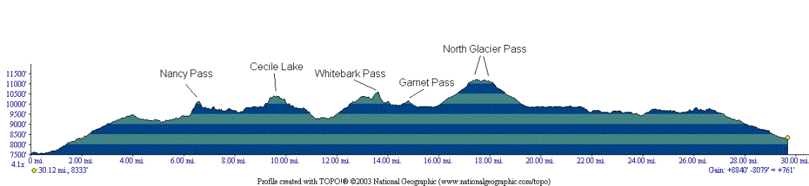
The off-trail passes on this trip were mostly class 2 or class 1, and none presented any significant challenges. North Glacier Pass has a bunch of large talus on both sides, but nothing that takes it beyond class 2. There is a short section labeled class 3 between Minaret Lake and Cecile Lake, but this proved to be fairly straightforward and short. Much of the route that was supposed to be off-trail was so well traveled that a use trail could be followed, another indication of the popularity of this area for off-trail travel.
We had an option to climb either Mt. Ritter or Banner Peak, but we lost a day early in the trip due to weather and probably wouldn’t have tackled either of these peaks anyway. Speaking of weather, the trip started fairly cloudy, with some snow flurries the second day and some heavier snow the afternoon of the third day. A combination of the snow and the low clouds that would have blocked our views of the Minarets caused us to not move camp the third day. Fourth day had some low clouds in the afternoon but no precipitation where we were. The rest of the trip was nearly completely clear, typical Sierra weather!