Humphreys Basin 2025
August 12 – Piute Pass Trailhead to Muriel LakeAugust 13 – Muriel Lake to Tomahawk Lake
August 14 – Tomahawk Lake to Alsace Lake with Pilot Knob summit
August 15 – Alsace Lake to Elba Lake
August 16 – Elba Lake to Royce Lakes
August 17 – Royce Lakes to French Lake
August 18 – French Lake to Humphreys Lakes
August 19 – Humphreys Lakes to Piute Lake
August 20 – Piute Lake to Piute Pass Trailhead
This
year's trip started at the Piute Pass trailhead west of Bishop on the
eastern slope of the Sierra. The trip visited the same general
area we last explored in 1999. Most of the trip was on the west
side of the Sierra Crest, almost entirely within the John Muir
Wilderness. Every camp was between 11,000 and 12,000 feet
elevation (Elba Lake is slightly below 11,000 but close enough!)
The trip ended up being tougher than we expected. The most challenging areas were the saddle between Goethe Lake and Wahoo Lakes, summiting Pilot Knob, and Steelhead Pass. All had lots of talus, with the last two having sections of very large talus, which was hard to navigate. There were some class 3 moves required on both of these with the routes we chose, despite both being rated class 2.
Mt.
Humphreys (13,992 ft) dominates the entire area, as you will notice by
all of the pictures including it. It was visible every day at
some point, even when we weren't too close to it. We camped right
beneath it on our second last night.
Weather
was a bit stormy on and off. The first day we had some sprinkles
in the afternoon. Next two days there were localized dark clouds
with some thunder in the distance. Fourth day clouds
built and it started sprinkling around noon. It was a short day
for us so we were at camp shortly thereafter. It rained all
afternoon. Next day at Royce Lakes there were dark clouds but no
rain. After that the weather cleared out a bit. Our coldest
night was at Humphreys Lakes where it got down to 28F.
We saw marmots, pikas, and chipmunks in various places. A family of white-tailed ptarmigan was nesting near our campsite at Royce Lakes. Marmot Lake (where we did not see any marmots) had tadpoles and frogs.
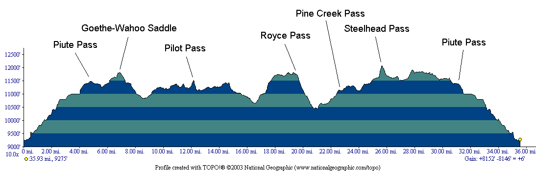
Note
that the elevation profile above does not include the climb to the top of Pilot Knob.
Go
here to see
all of the pictures with the same captions at Google Photos.
Map
Below is an interactive map of the trek. The red track is the main backpacking route, the other track is the Pilot Knob climb. The green tent symbols are our campsites. The trailhead is the "P" symbol on the right side. We did the loop clockwise.
Click here for a full-page version of the interactive map
Click here to download the kml file of the tracks to load into other software like Google Earth