Blue Canyon and Blackcap Basin 2022
August 19 – Rancheria Trailhead to Crown ValleyAugust 20 – Crown Valley to lower Blue Canyon
August 21 – lower Blue Canyon to upper Blue Canyon basin
August 22 – Blue Canyon Peak and upper lakes
August 23 – upper Blue Canyon basin to Portal Lake
August 24 – Blackcap Basin
August 25 – Portal Lake to Halfmoon Lake
August 26 – Halfmoon Lake to Woodchuck Creek
August 27 – Woodchuck Creek to Rancheria Trailhead
This
year's trip visited Crown Valley, Blue Canyon, and Blackcap
Basin. Crown Valley and Blackcap Basin are in the John Muir
Wilderness of the Sierra National Forest. Blue Canyon is in Kings
Canyon National Park. Neither of us had ever been to any of the
areas on this trip.
We
first visited Crown Valley and its cows. The trail condition was
fairly good up to this point, with a few downed trees to go
around. Past Crown Valley the trail got more difficult to follow,
with many downed trees in some areas. We fought our way through
and finally arrived at the bottom of Blue Canyon, where we decided to
camp for the second night. The trail following the canyon
upstream was a bit better with fewer downed trees. Eventually the
trail ended anyway as we got to the third night camp near
treeline. We did a day hike the next day in upper Blue Canyon,
summiting Blue Canyon Peak (11,860 ft) and visiting all of the larger
lakes in the upper basin. Next day we crossed back out of the
national park over Mantle Pass and found our way to Portal Lake, the
lowest lake in Blackcap Basin where we set up camp for two
nights. A day hike the next day visited many of the lakes of
Blackcap Basin. Again on trail, we followed it to Halfmoon Lake
above the North Fork Kings River canyon. This trail was in much
better shape, with only a few downed trees. The next two days we
headed back to the trailhead over Crown Pass and through Woodchuck
Country.
We saw only a total of four people on this trip, including at the trailhead, which was empty when we arrived. Two people camped near us our second night at Portal Lake (day 6), and we saw two more people near the trailhead on our last day. Weather was good, usually with some clouds but no rain at all and no smoke! There was a bit of thunder to the east in late afternoon at Halfmoon Lake. Nighttime temperatures were mostly comfortable.
Pikas
were most concentrated in the upper basin of Blue Canyon, with quite a
few in the rock slope behind our camp, but I never got any
pictures. There were some on the slope above Portal Lake, but I
only got pictures of marmots up there. We saw a frog near Pearl
Lake.
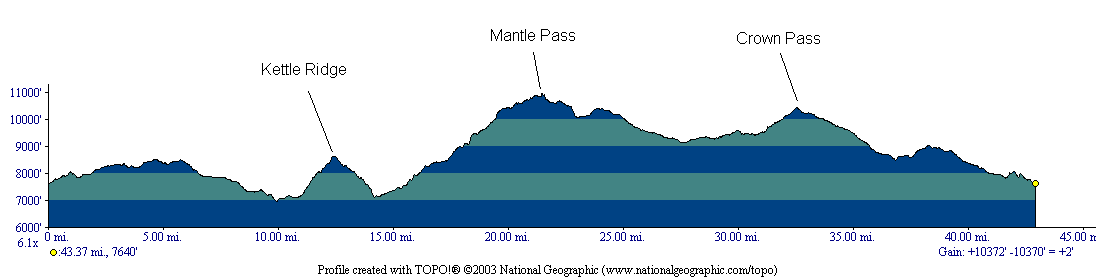
Note
that the elevation profile above does not include the two day hikes
we did (upper Blue Canyon basin and Blackcap Basin).
Go
here to see
all of the pictures with the same captions at Google Photos.
Map
Below is an interactive map of the trek. The red track is the main backpacking route, the other tracks are day hikes. The green tent symbols are our campsites. The trailhead is the "P" symbol on the left side. We did the loop counter-clockwise.
Click here for a full-page version of the interactive map
Click here to download the kml file of the tracks to load into other software like Google Earth