Seven Gables and The Pinnacles 2011
August 20 – Florence
Lake to Senger Creek
August 21 – Senger
Creek to Wampum Lake
August 22 – Wampum
Lake to Negit Lake
August 23 – Negit
Lake to Seven Gables Lakes
August 24 – Seven
Gables Lakes to Vee Lake
August 25 – Vee Lake
to Little Bear Lake
August 26 – Little
Bear Lake to Marie Lake
August 27 – Marie
Lake
to Lower Blayney Meadow
August 28 – Lower
Blayney Meadow to Florence Lake
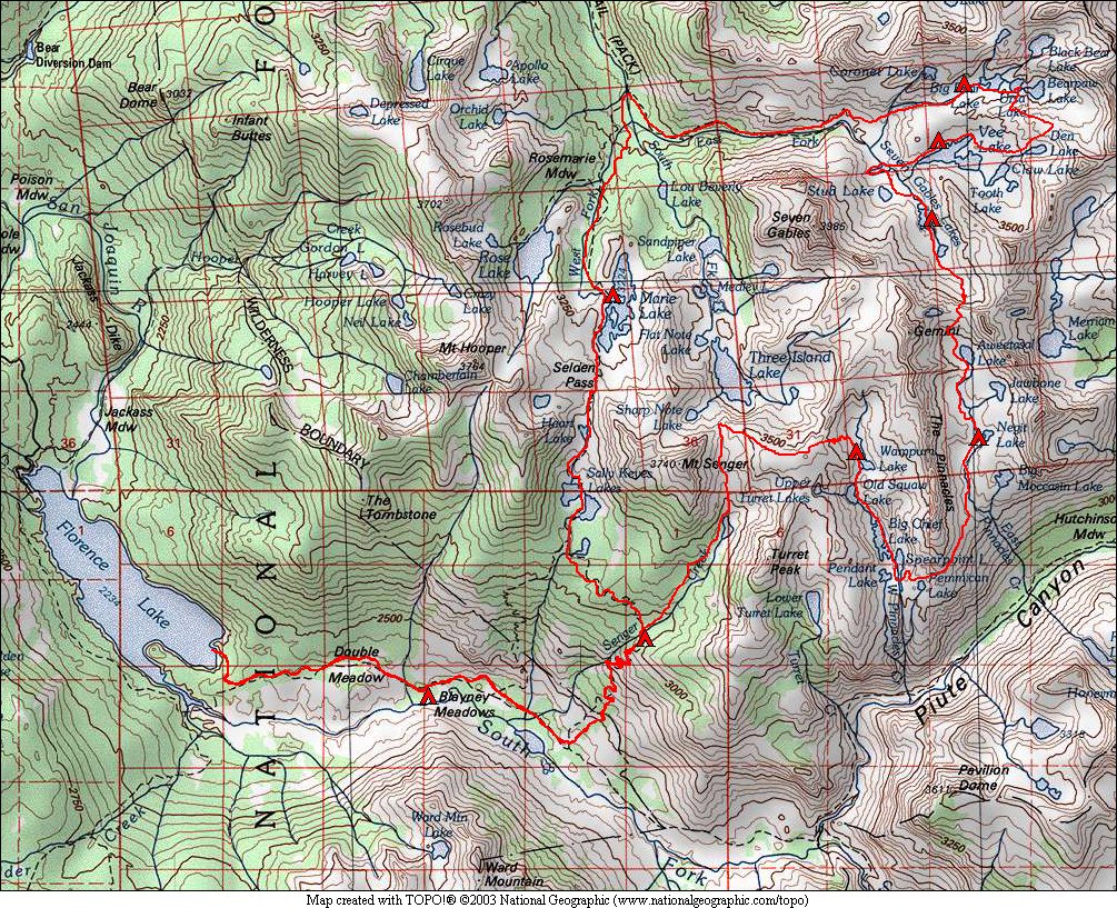
Since 1999, we had wanted to return to the Seven Gables area. This year was that chance. Seven Gables is a peak just to the north of Kings Canyon National Park in the John Muir Wilderness. The closest entry is via Florence Lake, which is reached by going beyond Shaver Lake and Huntington Lake (northeast of Fresno), and then continuing on a one-lane paved road to the end of Florence Lake. A ferry boat saves a few miles of hiking each way by delivering hikers to the opposite side of the lake where our trail started.
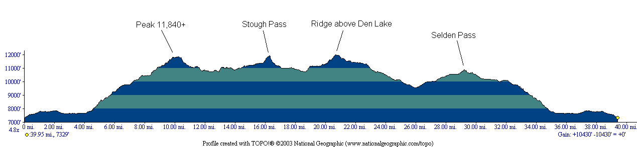
We planned to go all the way around Seven Gables, and a major ridge to its south that contains The Pinnacles. We would leave the trail where the John Muir Trail crosses Senger Creek, and follow this creek up to its headwaters and traverse over to West Pinnacles Creek. We would then visit the lakes along this creek, and then traverse around the south of The Pinnacles high above Piute Canyon over to East Pinnacles Creek. We would then follow that creek past its lakes and over Stough Pass (class 2). Due to the heavy snow last winter, we were concerned as to what we would find on the north side of this pass. After making our way down to Seven Gables Lake, we then planned to visit a number of the lakes in the Bear Lakes Basin area, some of which we had visited in 1999. After that, we would follow the East Fork of Bear Creek to meet the John Muir Trail north of Marie Lake. We would then follow the JMT back to the South Fork San Joaquin River and back to Florence Lake.
As usual, we had planned to climb a peak or two, those being Gemini and Seven Gables itself. We cancelled those plans due to visible snow, and the extra effort we had on our regular route due to the extra snow. Seven Gables looked like it would have been easily climbable from the west side with no snow on the route, but our plan had been to climb from the east side.
Off-trail travel was mostly fairly easy, with a couple of more challenging sections. The descent to Wampum Lake was made more challenging due to the snow hanging around. The descent from Stough Pass was quite dicey in spots, with some class 3 moves. We were restricted on this descent due to the lingering steep snowfields that we stayed off of. Descending from the ridge above Den Lake to Bearpaw Lake, while not difficult technically, was a challenge finding a route that did not require crossing a steep snow field. A snow field covered most of the north side of this ridge. The route from Seven Gables Lakes down to the JMT had some large sections of talus hopping that we weren't expecting, but they were not difficult (at least if one is used to talus hopping!).
The weather was good throughout most of the trip. We got a few sprinkes around Pemmican Lake on day 3, and some good rain in the evening at Marie Lake on day 6, which we waited out in our tents. Other than that, sky was either completely clear or partly cloudy each day.
Regarding animals, marmots were
mostly absent on this trip, but we did find one at Little Bear Lake and
several at Heart Lake. Pikas were living in a rock pile near
Seven Gables Lakes, and we heard them in several other spots. A
friendly (hungry) squirrel kept us company at Vee Lake. And the
mosquitos were nearly constant companions due to the wet winter.
Normally mosquitos are nonexistant in the Sierra in late August.
Also, it was good to see a nice crop of tadpoles at the lowest Seven
Gables Lake!