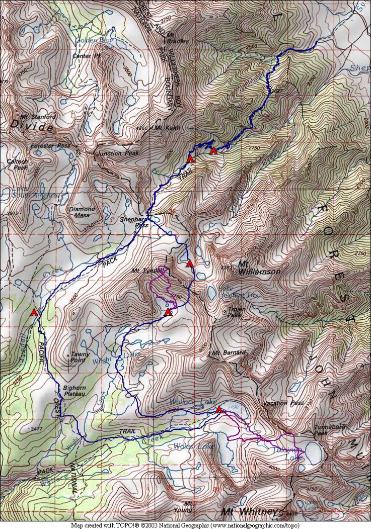
Mt. Tyndall and Wallace Basin 2009
August 21 – Symmes Creek to Mahogany Flat
August 22 – Mahogany Flat to Tyndall Creek
August 23 – Tyndall Creek to Wallace Lake
August 24 – Tulainyo and Wales Lakes
August 25 – Wallace Lake to Upper Wright Lake
August 26 – Mt. Tyndall summit
August 27 – Upper Wright Lake to Williamson Bowl
August 28 – Williamson Bowl to Anvil Camp
August 29 – Anvil Camp to Symmes Creek
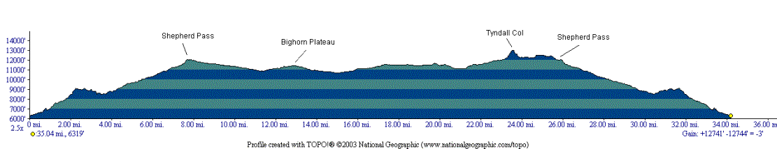
An area we had not explored yet was the Shepherd Pass area. This pass is on the Sierra Crest between the northeast corner of Sequoia National Park and Inyo National Forest. The trail in is a grueling climb, starting at around 6300 feet, with the pass at 12000 feet. To top it off, there is an intermediate saddle to cross with a loss of 500 feet on the way up as you cross from Symmes Creek to Shepherd Creek. We took our time getting up to this pass, with one camp around half way up at Mahogany Flat.
Our off-trail destinations for this trip included the upper Wallace Basin and the highest named lake in the Sierra, Tulainyo Lake. We had planned to travel through here on our 2007 trip, but we weren’t comfortable with some of the off-trail required. So this trip gave us another chance to visit the area. A highlight of the trip was a climb of Mt. Tyndall, which at 14018 feet is one of California’s “14ers”. We climbed this peak from Wright Basin, a less popular but probably easier route than the north side from Shepherd Pass. We also planned to traverse through Willimason Bowl, avoiding the Bighorn Sheep closure area by staying to its west side.
We had lots of off-trail travel on this trip, with one significant pass, Tyndall Col. This is a class 2 pass that traverses the Sierra Crest at 13000 feet just south of Mt. Tyndall. This pass was an endurance challenge on both sides, with steep chutes on the east side reminiscent of Cox Col from our 2004 trip. We both used a rope to lower our packs through this section. Other off-trail travel on the trip was mostly fairly easy walking, with some sections of talus to navigate.
Most of the trip was above 11000 feet, contrasted to last year’s trip which only reached a high of 11300 feet. Our highest camp was in Williamson Bowl at an elevation of around 12300 feet. We camped near a small pond covered with ice!
Our most frequent animal on this trip was probably the marmot. They were especially abundant in the area west of Shepherd Pass. Pika were also abundant wherever talus piles were nearby, but were more often heard than seen. We did see a few though, a couple of which I was able to photograph.
Weather was cooperative, once we decided to reverse the direction of the trip. We had a bit of sprinkles, and fairly consistent sprinkles through the second night at Tyndall Creek. A bit of hail fell the third day at Wallace Lake in the late afternoon. After this, the rain was pretty much done although low clouds stuck around for another two days. But our off-trail walking was on dry rocks, which was why we reversed the direction to put the off-trail at the end of the trip rather than at the beginning.