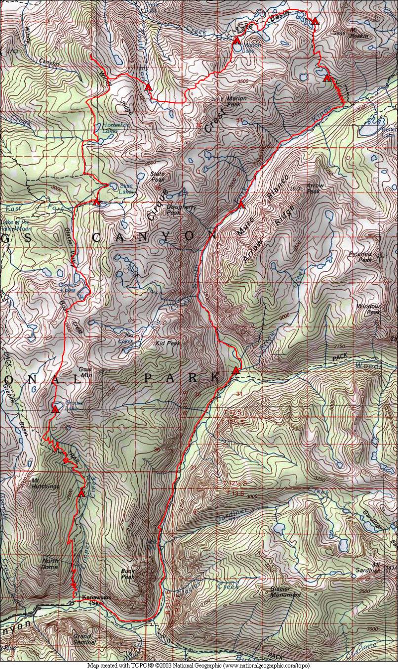
Cartridge Pass and Muro Blanco 2006
August 17 – Roads End to Tent Meadow
August 18 – Tent Meadow to Grouse Lake
August 19 – Grouse Lake to State Lakes
August 20 – State Lakes to S. Fork Cartridge Creek
August 21 – S. Fork Cartridge Creek to Marion Lake
August 22 – Marion Lake to Lake Basin
August 23 – Lake Basin over Cartridge Pass
August 24 – Into the Muro Blanco Canyon
August 25 – Muro Blanco Canyon to Paradise Valley
August 26 – Paradise Valley to Roads End
This trip was kind of hard to give a name to, as we covered so many different areas. The first segment of the trip followed the beginning of the Sierra High Route, a mostly off-trail route described in a book of that name by Steve Roper. This route extends for 195 miles, starting at Roads End in Kings Canyon National Park and ending north of Yosemite at Twin Lakes. We followed the route over its first five passes, and left it in Lake Basin, where the Sierra High Route goes over Frozen Lake Pass to Upper Basin where it meets the John Muir Trail. Instead we left Lake Basin via Cartridge Pass and took the rugged canyon of the Muro Blanco back to the trail in Paradise Valley, which leads back to our starting point at Roads End. The trip was Ron and Steve’s ninth annual trip in the Sierra.
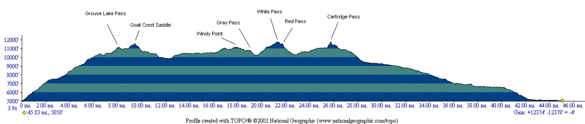
The trip crossed a total of six off-trail passes, but no passes on-trail. None of the passes were particularly difficult, all being class 2 or lower. Cartridge Pass used to have a trail leading over it (this was the John Muir Trail before the section passing Palisade Lakes and Mather Pass was completed in 1938). The trail was still very visible past the upper lakes in Lake Basin, up and over the pass, and all the way down to the South Fork of the Kings River canyon. This made our travel in this area a bit easier. This trip was probably the most difficult trip we have done to date, partially due to the large number of passes, but mostly due to our descent of the Muro Blanco canyon.
We saw almost nobody on the off-trail parts of this trip, exceptions being two people just below White Pass and then a few people on the south side of Cartridge Pass. The Muro Blanco canyon had almost no signs of people at all, but plenty of signs of bears, although we saw no actual bears there. Ron did see a bear cub on the very first day of the trip. We also saw a rattlesnake on the last day, and an interesting frog on the south side of Cartridge Pass. We encountered plenty of deer, heard pika but didn’t see any, and saw one marmot on the last day, down around 6000 feet.
We had planned to climb a peak near Marion Lake (either peak 11440 ft. or Marion Peak), but instead hiked out to Windy Point a few days earlier and enjoyed the view there to take the place of the peak. We used the peak climbing “layover day” to instead have two short backpacking days that allowed for a night in Lake Basin. This trip was a day longer than our usual 9-day bear canister-limited trip. We split the long initial uphill into 2½ days by doing the first 2800 feet elevation gain after driving down on the first day, and took advantage of the steel bear box at Tent Meadow for our overflow food before it all fit in our canisters.
We lucked out again on this trip and had beautiful weather the entire time. There were a few small fires burning in the area that made views in the distance hazy at times, but we could never smell any smoke.
Ron was busy cataloging wildflowers that we saw on this trip. Click here to see his list of flowers spotted.