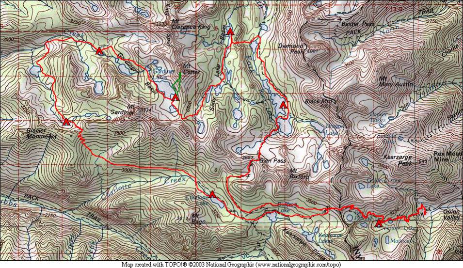
Mt. Cotter and the Gardiner Basin 2005
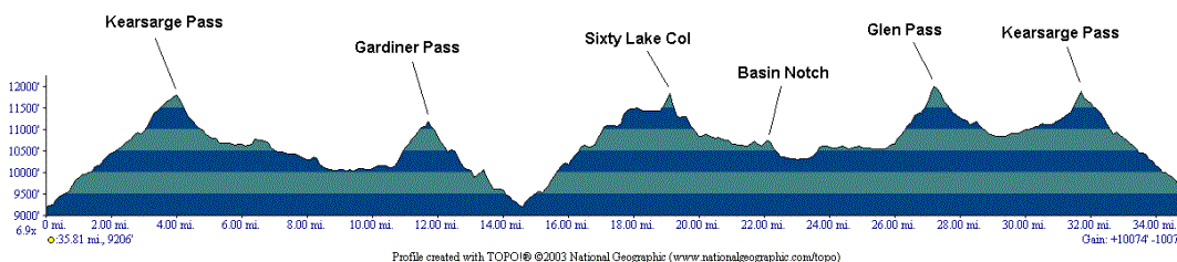
August 19 – Onion Valley to Charlotte Lake
August 20 – Charlotte Lake to below Gardiner Pass
August 21 – Gardiner Creek
August 22 – Gardiner Basin
August 23 – Mt. Cotter summit
August 24 – Gardiner Basin to Sixty Lake Basin
August 25 – Sixty Lake Basin to Rae Lakes
August 26 – Glen Pass and Kearsarge Pass
August 27 – Back to Onion Valley
Gardiner Basin is a little-traveled basin in the middle of a very popular area. It is not far from the John Muir Trail, and is smack in the middle of the Rae Lakes Loop. Despite its proximity to these popular areas, we saw only two people, from a distance, while in the Gardiner Creek and Gardiner Basin areas. We saw plenty of people on this trip, however, at the start and end on the Kearsarge Pass Trail and John Muir Trail. Kearsarge Pass is a very popular entry point from the Eastern Sierra as the trailhead is high (9200 feet) and it is close to these popular areas.
This trip took us into Gardiner Basin, with a climb (nearly) to the summit of Mt. Cotter (12,721 feet) from the high lakes in the basin. It also took us to Sixty Lake Basin, a bit more crowded due to a trail leading there. We found the northern part of this basin uncrowded as the trail all but disappears there. Finally, this trip took us back to Rae Lakes, which we visited in 1995 as part of a trip from Taboose Pass to Mt. Whitney. On that trip, Rae Lakes to us was a hail storm, as that is what we had there. We wanted to return to see what Rae Lakes is like with more favorable weather. On this trip, we got that favorable weather.
Despite being a season of unsettled weather, we somehow managed to pick a sequence of 9 days where the weather was beautiful! We heard stories of day-long rain, snow, and hail in the days before we started our trip. People coming over Kearsarge Pass on our first day spoke of a hailstorm the previous evening, when we were at the car campground in Onion Valley, where we got only a drop or two of rain.
Three off-trail passes were crossed on this trip. Gardiner Pass, at 11,200 feet, had a trail over it many years ago. The trail was still visible on and off, but the section leading down from the pass and the section from the lake at 9500 feet down to Gardiner Creek were most helpful. A lot of the travel both before and after this pass was in brush and trees (the pass itself has trees on it), so was more difficult than travel above treeline, where you don’t need to contend with brush and generally you can see far ahead to where you’re going. Given time, though, we were able to find our way down to Gardiner Creek at around 9000 feet, then up to Gardiner Basin, where a very large lake dominates. A “day trip” up Mt. Cotter was taken from our camp at this lake. The second off-trail pass was Sixty Lake Col (11,700 feet), which led from Gardiner Basin to Sixty Lake Basin. This pass is class 2, and was not difficult. Talus hopping on the west side, with the east side over talus and grass. Passing around the west shore of the long lake was a bit challenging as we had to go uphill to avoid cliffs going into the lake. The third and final off-trail pass was Basin Notch (10,700 feet), a small pass leading from Sixty Lake Basin to Arrowhead Lake on the John Muir Trail. This pass had just a small amount (100 feet or so) of uphill on the west side, and a steep and challenging descent on the east side. Soon we were at the trail, which we would follow all the way back to the trailhead.