Alta Peak and Tableland 2008
August 15 – Wolverton to Mehrten Meadow
August 16 – Alta Peak and Alta Meadow
August 17 – Alta Meadow to Moose Lake
August 18 – Moose Lake to Lonely Lake
August 19 – Lonely Lake to Big Bird Lake
August 20 – Big Bird Lake to Tableland Rim
August 21 – Tableland Rim and Table Meadows
August 22 – Table Meadows to Pear Lake
August 23 – Pear Lake to Wolverton
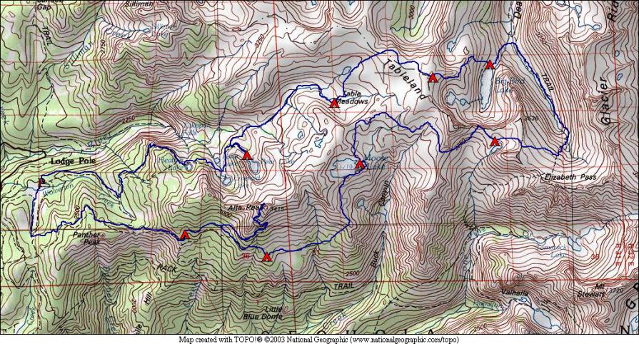
This year’s trip took us into the Tableland area of Sequoia National Park. A land of granite slabs, and a land of coyotes. Off-trail travel in this area was fairly easy, as mentioned, slabs made a lot of the walking no more difficult than a trail (even easier than some of the trail we encountered). And we saw coyotes for the first time in Sequoia/Kings Canyon: on Alta Peak, in Alta Meadow, and at Pear Lake. Coyotes were also heard at night from a few of our camps. Marmot and Pika were also abundant in this area.
After the last couple of annual trips, this one was considerably easier. The highest we reached was around 11300 feet, and the total mileage around 36 miles over 9 days. Many days we had to extend our breaks to avoid reaching our planned camp too early. But the scenery did not disappoint!
The trip started and ended at Wolverton, a trailhead reached from the west side of Sequoia National Park. We crossed the Sequoia / Kings Canyon boundary (and back) in the middle of the trip, spending two nights on the Kings Canyon side. The Wolverton trailhead is at 7200 feet, which was the lowest point of the trip.
We followed trails for the first two days, including hiking to the top of 11200 foot Alta Peak among many day hikers. The third day we left the trail to head toward large Moose Lake, traces of an old trail were visible from time to time. We continued around the top of Buck Canyon and into the basin holding Lonely Lake, which was indeed lonely. We then went over Horn Col to meet the Elizabeth Pass Trail. We followed the trail down into Deadman Canyon, where we left it at Upper Ranger Meadow to climb to Big Bird Lake. We climbed from there up to the Tableland Rim at 11200 feet, where we camped at a small lake with panoramic views nearby! Then we headed down to Table Meadows and finally back to the trail to Pear Lake. There were plenty of day hikers our last day, as we passed the Watchtower and headed back to the trailhead.
Weather was pretty good, with some haze the first few days. I suspect the haze was from humidity, not smoke, as we didn’t smell smoke. Days and nights were warm. We got about 30 minutes of rain at our first camp, and a few sprinkles as we arrived at our second camp. That was the last rain we saw. The third night (Moose Lake) the temperature dropped below freezing, and the humidity apparently fell out of the air as dew. In the morning some of our gear was wet and some had frost. We had a couple more cold nights (but no more dew), then things warmed up again.